The North America LiDAR market is witnessing strong momentum as industries increasingly rely on high-precision spatial data for mapping, surveying, infrastructure monitoring, and automation. LiDAR (Light Detection and Ranging) technology enables accurate 3D visualization by using laser pulses to measure distances, making it a critical tool across construction, transportation, utilities, defense, and environmental applications. With advancements in sensor technology and growing adoption of aerial and ground-based platforms, the North American LiDAR ecosystem continues to evolve rapidly.
North America LiDAR Market in terms of revenue is estimated to be worth $1.25 billion in 2025 and is poised to reach $USD 4.8 billion by 2030, growing at a CAGR of 30.9% during the forecast period.
Market Overview and Growth Drivers
North America remains one of the most mature and technologically advanced LiDAR markets globally. The region benefits from strong investments in smart infrastructure, autonomous systems, geospatial intelligence, and digital twin technologies. Government initiatives supporting infrastructure modernization, combined with rising demand for accurate terrain and asset data, are accelerating LiDAR adoption across both public and private sectors.
Technological progress, especially in sensor miniaturization and data processing software, is also reducing deployment costs and expanding use cases, positioning the North America LiDAR market for sustained growth through 2030.
Download PDF Brochure @ https://www.marketsandmarkets.com/pdfdownloadNew.asp?id=2472587
Market Segmentation by Installation
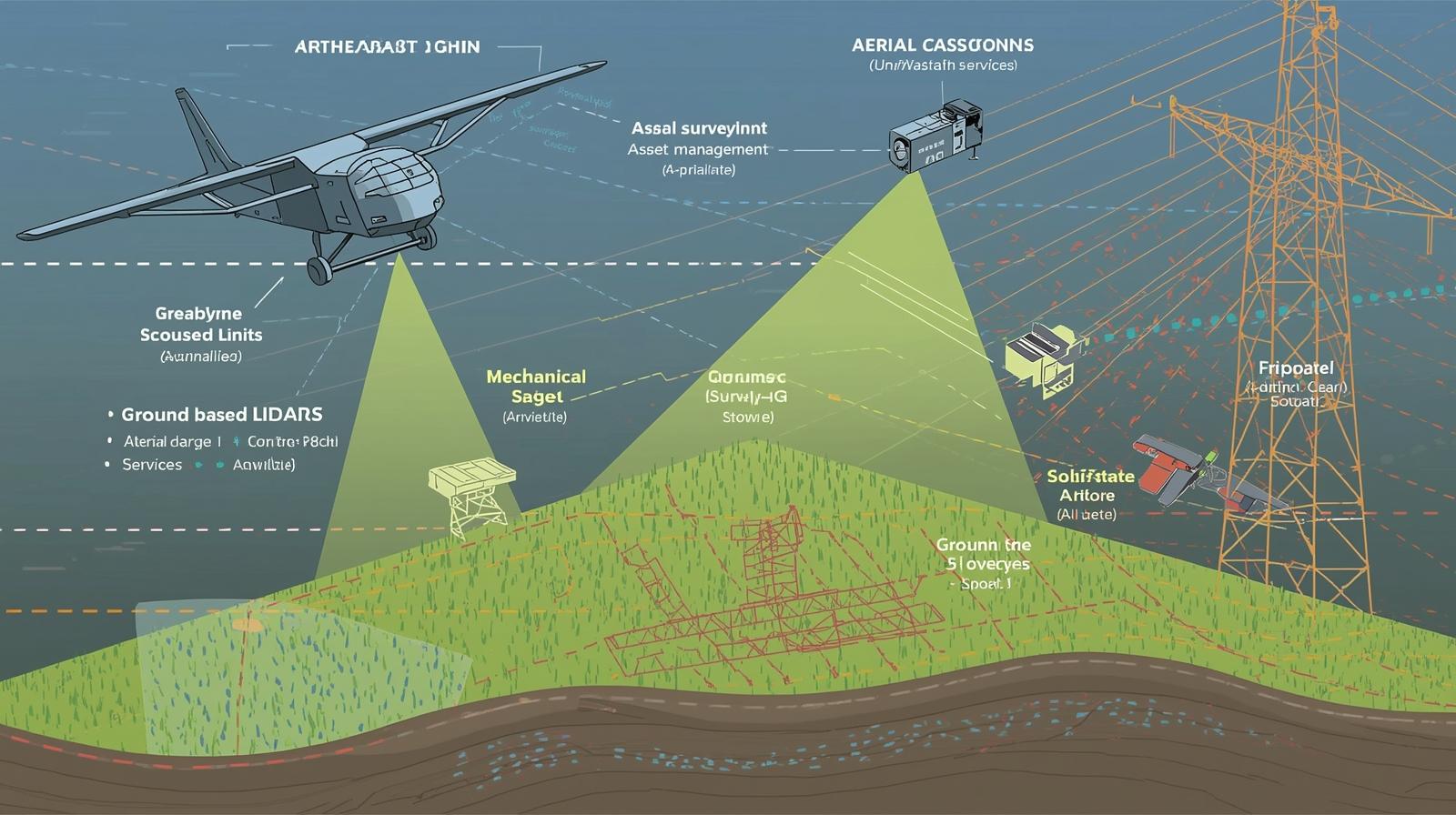
Airborne LiDAR
Airborne LiDAR systems are deployed on aircraft, helicopters, and unmanned aerial vehicles (UAVs). These systems are widely used for large-scale data collection, offering rapid coverage over extensive geographical areas. In North America, airborne LiDAR plays a crucial role in topographic mapping, forestry analysis, flood risk assessment, and transportation corridor planning. The growing use of drones for cost-effective aerial surveys is further strengthening this segment.
Ground-Based LiDAR
Ground-based LiDAR includes stationary, mobile, and vehicle-mounted systems designed for detailed, close-range data capture. This installation type is commonly used for infrastructure inspection, construction monitoring, industrial site analysis, and urban modeling. Ground-based LiDAR systems deliver high-resolution outputs, making them ideal for asset-level analysis and precision surveying projects.
Market Segmentation by Type
Mechanical LiDAR
Mechanical LiDAR systems utilize rotating components to provide wide field-of-view scanning. These systems are well-established and continue to be used extensively in surveying, mapping, and traditional geospatial applications. Their proven accuracy and reliability make them a preferred choice for many large-scale projects in North America.
Solid-State LiDAR
Solid-state LiDAR represents a newer generation of sensors that operate without moving parts. This design enhances durability, reduces maintenance requirements, and enables compact form factors. In North America, solid-state LiDAR is gaining strong traction in automotive, robotics, and industrial automation applications, where reliability and scalability are critical.
Market Segmentation by Range
Short-Range LiDAR
Short-range LiDAR systems are designed for high-precision measurements over limited distances. These sensors are commonly used in indoor mapping, warehouse automation, robotics, and industrial inspection. Their ability to capture fine details makes them valuable in manufacturing and logistics environments.
Medium-Range LiDAR
Medium-range LiDAR is widely applied in transportation infrastructure, urban planning, and mobile mapping. This range category offers a balance between coverage and resolution, supporting applications such as road inspection, rail monitoring, and asset documentation across cities and industrial zones.
Long-Range LiDAR
Long-range LiDAR systems are used for extensive distance measurements and are essential in airborne surveying, defense applications, and large-scale terrain mapping. In North America, long-range LiDAR supports national mapping initiatives, environmental monitoring, and strategic infrastructure planning.
Market Segmentation by Service
Aerial Surveying
Aerial LiDAR surveying services form a core part of the North America LiDAR market. These services enable rapid data acquisition for topographic mapping, land use analysis, and environmental assessments. Aerial surveys are widely adopted by government agencies, urban planners, and energy companies.
Ground-Based Surveying
Ground-based LiDAR surveying focuses on detailed measurements of structures, facilities, and terrain. These services are essential in construction, mining, industrial inspection, and heritage preservation. The demand for accurate as-built documentation and project validation is driving growth in this service category.
Asset Management
LiDAR-enabled asset management services help organizations monitor and maintain critical infrastructure such as bridges, roads, pipelines, power lines, and industrial facilities. By providing accurate 3D models and condition data, LiDAR supports predictive maintenance, reduces operational risks, and improves lifecycle management.
Other Services
Additional LiDAR services include data processing, modeling, GIS integration, and customized analytics. These value-added services allow stakeholders to transform raw LiDAR data into actionable insights, enhancing decision-making across various industries.
Future Outlook
The future of the North America LiDAR market is shaped by expanding applications, technological innovation, and increasing reliance on data-driven decision-making. The integration of LiDAR with artificial intelligence, cloud computing, and digital twin platforms is expected to unlock new opportunities across smart cities, autonomous systems, and infrastructure resilience planning.
As industries continue to prioritize accuracy, efficiency, and safety, LiDAR will remain a foundational technology supporting the digital transformation of North America’s built and natural environments.
FAQs: North America LiDAR Market
1. What is the North America LiDAR market?
The North America LiDAR market includes technologies and services that use Light Detection and Ranging (LiDAR) to capture accurate 3D spatial data. The market supports applications such as mapping, surveying, infrastructure inspection, asset management, autonomous systems, and environmental monitoring.
2. What are the key drivers of the North America LiDAR market?
Major growth drivers include infrastructure modernization, rising adoption of autonomous and smart technologies, increased demand for high-precision geospatial data, expansion of drone-based surveying, and advancements in LiDAR sensor technology.
3. How is the market segmented by installation type?
The market is segmented into:
- Airborne LiDAR: Installed on aircraft, helicopters, and drones for large-area mapping.
- Ground-based LiDAR: Includes stationary, mobile, and vehicle-mounted systems for detailed, close-range data capture.
4. What are the main LiDAR types used in North America?
The market is divided into:
- Mechanical LiDAR: Uses rotating components and is widely used in traditional surveying and mapping.
- Solid-state LiDAR: Has no moving parts and offers improved durability, compact design, and scalability, especially for automotive and industrial applications.
- About MarketsandMarkets™
MarketsandMarkets™ has been recognized as one of America’s Best Management Consulting Firms by Forbes, as per their recent report.
MarketsandMarkets™ is a blue ocean alternative in growth consulting and program management, leveraging a man-machine offering to drive supernormal growth for progressive organizations in the B2B space. With the widest lens on emerging technologies, we are proficient in co-creating supernormal growth for clients across the globe.
Today, 80% of Fortune 2000 companies rely on MarketsandMarkets, and 90 of the top 100 companies in each sector trust us to accelerate their revenue growth. With a global clientele of over 13,000 organizations, we help businesses thrive in a disruptive ecosystem.
The B2B economy is witnessing the emergence of $25 trillion in new revenue streams that are replacing existing ones within this decade. We work with clients on growth programs, helping them monetize this $25 trillion opportunity through our service lines – TAM Expansion, Go-to-Market (GTM) Strategy to Execution, Market Share Gain, Account Enablement, and Thought Leadership Marketing.
Built on the ‘GIVE Growth’ principle, we collaborate with several Forbes Global 2000 B2B companies to keep them future-ready. Our insights and strategies are powered by industry experts, cutting-edge AI, and our Market Intelligence Cloud, KnowledgeStore™, which integrates research and provides ecosystem-wide visibility into revenue shifts.
To find out more, visit www.MarketsandMarkets™.com or follow us on Twitter , LinkedIn and Facebook .
Contact:
Mr. Rohan Salgarkar
MarketsandMarkets™ INC.
1615 South Congress Ave.
Suite 103, Delray Beach, FL 33445
USA: +1-888-600-6441