The global space industry is undergoing a profound transformation as governments, commercial space companies, and research organizations seek increasingly accurate ways to observe Earth, explore planetary bodies, and support autonomous space missions. At the center of this technological evolution is Light Detection and Ranging (LiDAR), a sensing technology that is redefining precision in space-based applications.
The Space LiDAR Market has emerged as one of the most dynamic segments within the space technology ecosystem. From Earth observation and atmospheric profiling to lunar exploration and autonomous spacecraft navigation, LiDAR systems are enabling unprecedented levels of accuracy and situational awareness.
According to MarketsandMarkets, the Space LiDAR Market was valued at approximately USD 750 million in 2025 and is projected to reach USD 1.75 billion by 2032, growing at a CAGR of 12.9% during the forecast period. The expansion is driven by increasing deployments of Low Earth Orbit (LEO) satellite constellations, rising investments in commercial lunar programs, growing demand for rendezvous and docking technologies, and the adoption of autonomous navigation systems for future space missions.
As space missions become more complex and data-intensive, the Space LiDAR Market is positioned to play a critical role in the future of orbital operations, planetary exploration, and environmental intelligence.
Understanding Space LiDAR Technology
LiDAR operates by transmitting laser pulses toward a target and measuring the time required for those pulses to return after reflection. This process enables highly precise measurements of distance, elevation, velocity, and object characteristics.
Unlike traditional optical imaging systems, LiDAR generates detailed three-dimensional point clouds that provide highly accurate spatial information.
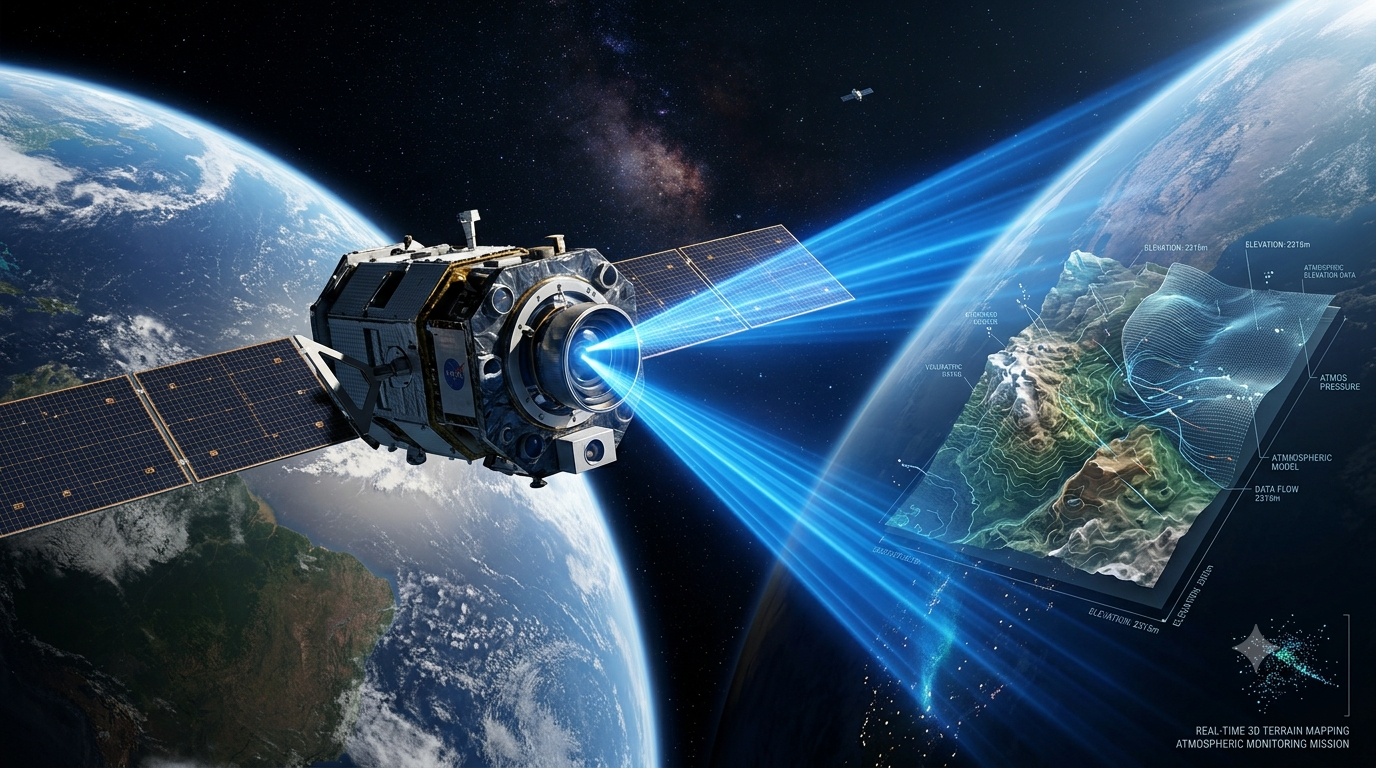
In space applications, LiDAR systems support:
- Earth observation
- Terrain mapping
- Atmospheric monitoring
- Spacecraft navigation
- Rendezvous and docking operations
- Lunar exploration
- Asteroid characterization
- Climate monitoring
The growing need for high-resolution geospatial intelligence continues to drive investment in the Space LiDAR Market across both government and commercial sectors.
Key Drivers Accelerating the Space LiDAR Market
Expansion of LEO Satellite Constellations
The rapid deployment of LEO satellites is among the strongest growth drivers for the Space LiDAR Market.
Satellite operators are increasingly integrating LiDAR payloads into Earth observation missions to provide detailed terrain mapping, environmental monitoring, and infrastructure analysis.
Compared with traditional imaging technologies, LiDAR offers:
- Superior elevation accuracy
- Three-dimensional mapping capabilities
- Enhanced terrain penetration
- High-resolution spatial intelligence
As LEO constellations continue to expand globally, demand for advanced LiDAR sensors is expected to rise significantly.
Growth of Commercial Lunar Programs
Global interest in lunar exploration has accelerated substantially.
Government initiatives and private-sector programs are creating demand for highly accurate surface mapping technologies capable of supporting:
- Landing site selection
- Hazard avoidance
- Resource identification
- Lunar infrastructure development
MarketsandMarkets identifies lunar and planetary surface mapping as one of the highest-growth applications within the Space LiDAR Market.
Increasing Demand for Autonomous Space Operations
Future space missions will increasingly depend on autonomous decision-making systems.
LiDAR technology enables spacecraft to perform:
- Autonomous navigation
- Obstacle detection
- Proximity operations
- Precision landing
- Docking procedures
As space agencies pursue deep-space exploration and orbital servicing missions, autonomous sensing capabilities are becoming mission-critical components of modern spacecraft architectures.
Download PDF Brochure @ https://www.marketsandmarkets.com/pdfdownloadNew.asp?id=22643480
Earth Observation Remains a Core Application
Earth observation continues to represent one of the largest revenue-generating segments within the Space LiDAR Market.
Organizations worldwide rely on LiDAR-derived data to support environmental monitoring, infrastructure planning, disaster response, and climate research.
Terrain Mapping
LiDAR enables highly accurate digital elevation models that support:
- Infrastructure development
- Transportation planning
- Urban expansion
- Resource management
These capabilities are particularly valuable in regions where traditional surveying methods are difficult or costly to implement.
Forest and Biomass Monitoring
Forests play a crucial role in carbon sequestration and climate regulation.
Space-based LiDAR systems can accurately measure:
- Forest canopy height
- Biomass density
- Vegetation structure
- Deforestation patterns
Such data supports conservation efforts and international carbon accounting initiatives.
Coastal and Flood Risk Assessment
LiDAR-derived elevation data helps governments and researchers understand flood risks, coastal erosion patterns, and sea-level changes.
As climate-related challenges intensify, these applications are becoming increasingly important contributors to the Space LiDAR Market.
The Rise of Rendezvous, Proximity Operations, and Docking (RPOD)
One of the fastest-growing segments in the Space LiDAR Market is Rendezvous, Proximity Operations, and Docking (RPOD).
Modern space missions increasingly require spacecraft to:
- Approach target vehicles
- Dock autonomously
- Service satellites
- Remove orbital debris
- Conduct in-space assembly
LiDAR provides highly accurate real-time positioning data that enables spacecraft to safely perform these complex maneuvers.
MarketsandMarkets identifies RPOD as both the dominant and fastest-growing application segment due to increasing investments in orbital servicing and debris removal missions.
Climate Monitoring and Atmospheric Profiling
Climate science has become a major driver of the Space LiDAR Market.
Governments and research institutions require accurate environmental data to assess climate change and support sustainability initiatives.
Ice Sheet Monitoring
LiDAR systems measure:
- Ice thickness
- Glacier movement
- Surface elevation changes
- Polar ice loss
These measurements provide critical insights into global warming and sea-level rise.
Atmospheric Research
Advanced atmospheric LiDAR systems can analyze:
- Wind fields
- Aerosol concentrations
- Cloud structures
- Greenhouse gas distributions
Atmospheric profiling is becoming increasingly important as nations strengthen climate monitoring programs and emissions tracking initiatives.
Technological Innovations Shaping the Space LiDAR Market
Photon-Counting LiDAR
Photon-counting LiDAR represents one of the most disruptive innovations in the market.
This technology offers:
- Single-photon sensitivity
- Improved long-range performance
- Reduced power consumption
- Enhanced accuracy
These advantages make photon-counting systems particularly valuable for deep-space exploration and high-altitude Earth observation missions.
FMCW LiDAR
Frequency-Modulated Continuous Wave (FMCW) LiDAR is gaining traction due to its ability to measure both range and velocity simultaneously.
Key benefits include:
- Improved precision
- Reduced interference
- Enhanced navigation capabilities
- Better performance in challenging environments
As autonomous spacecraft become more common, FMCW solutions are expected to gain market share.
MEMS and Solid-State Architectures
Miniaturization remains a key trend in the Space LiDAR Market.
MEMS-based and solid-state LiDAR technologies help reduce:
- Size
- Weight
- Power consumption
- System complexity
These improvements make LiDAR increasingly suitable for CubeSats and small satellite platforms.
Regional Outlook
North America
North America currently dominates the Space LiDAR Market due to strong investments from:
- NASA
- U.S. Department of Defense
- Commercial satellite operators
- Space technology companies
Programs related to Earth observation, Artemis lunar missions, and space domain awareness continue to support regional growth.
Europe
Europe maintains a strong market position through initiatives led by:
- European Space Agency (ESA)
- Airbus Defence and Space
- National space agencies
Atmospheric monitoring and climate research remain major growth drivers throughout the region.
Asia-Pacific
Asia-Pacific is projected to be the fastest-growing regional market.
Investments from:
- China
- India
- Japan
- South Korea
are driving increased demand for Earth observation satellites, lunar missions, and advanced sensing technologies.
Competitive Landscape
The Space LiDAR Market features participation from leading aerospace and defense organizations, including:
- Ball Aerospace (Boeing)
- RTX (Raytheon Technologies)
- Teledyne Technologies
- Fibertek
- Coherent Corp.
- Hexagon AB
- Moog Inc.
Competition is increasingly focused on:
- Sensor performance
- Autonomous capabilities
- Miniaturization
- AI integration
- Radiation-hardened designs
Companies capable of delivering modular, software-defined, and AI-enabled LiDAR solutions are expected to gain a significant competitive advantage over the coming decade.
Future Outlook
The future of the Space LiDAR Market is closely aligned with broader trends shaping the global space economy.
Key growth opportunities include:
- Commercial lunar exploration
- On-orbit servicing missions
- Space debris management
- Autonomous spacecraft navigation
- Climate monitoring initiatives
- Earth observation constellations
As the industry moves toward more autonomous and data-driven missions, LiDAR technology will become increasingly indispensable.
The combination of advanced sensing, artificial intelligence, and satellite miniaturization is expected to unlock new applications and revenue streams across the Space LiDAR Market throughout the forecast period.
Conclusion
The Space LiDAR Market is transforming how humanity observes Earth and explores space. By delivering precise three-dimensional intelligence from orbit, LiDAR systems are supporting breakthroughs in environmental monitoring, climate science, lunar exploration, autonomous navigation, and orbital servicing.
With the market projected to more than double by 2032, organizations investing in next-generation LiDAR technologies are well positioned to capitalize on the growing demand for high-precision space sensing solutions. As exploration ambitions expand beyond Earth orbit and the commercial space economy matures, LiDAR will remain one of the foundational technologies enabling the next generation of space missions.
Frequently Asked Questions (FAQs)
1. What is the Space LiDAR Market?
The Space LiDAR Market refers to the global industry focused on the development, deployment, and commercialization of LiDAR systems for satellites, spacecraft, lunar missions, planetary exploration, atmospheric monitoring, and Earth observation applications.
2. How large is the Space LiDAR Market?
According to MarketsandMarkets, the Space LiDAR Market was valued at approximately USD 750 million in 2025 and is projected to reach USD 1.75 billion by 2032, growing at a CAGR of 12.9%.
3. What are the major applications of Space LiDAR?
Key applications include Earth observation, terrain mapping, atmospheric profiling, climate monitoring, lunar exploration, asteroid mapping, autonomous navigation, and rendezvous, proximity operations, and docking (RPOD).
4. Which region leads the Space LiDAR Market?
North America currently holds the largest market share due to strong investments from NASA, defense agencies, and commercial space companies. Asia-Pacific is expected to experience the fastest growth through 2032.
5. What technologies are driving innovation in the Space LiDAR Market?
Photon-counting LiDAR, FMCW LiDAR, MEMS-based architectures, solid-state sensors, AI-powered processing systems, and software-defined LiDAR platforms are among the key innovations shaping the future of the Space LiDAR Market.