The LiDAR Market is entering a period of rapid expansion as industries increasingly adopt high-precision 3D sensing, autonomous systems, advanced mapping, smart infrastructure, and digital transformation technologies. LiDAR, or Light Detection and Ranging, uses laser pulses to measure distances and generate highly detailed three-dimensional representations of physical environments.
According to MarketsandMarkets, The LiDAR market is projected to reach USD 12.79 billion by 2030 from USD 3.27 billion in 2025, at a CAGR of 31.3% Rising adoption in autonomous vehicles, advanced driver assistance systems (ADAS), environmental mapping, infrastructure development, surveying, and smart city projects is driving this rapid growth.
The evolution of LiDAR is also being accelerated by improvements in sensor accuracy, miniaturization, artificial intelligence (AI), cloud computing, robotics, unmanned aerial vehicles (UAVs), and 3D data processing. As a result, LiDAR is moving beyond traditional surveying applications and becoming an important sensing technology for connected and automated environments.
LiDAR Market Moves Toward Intelligent 3D Sensing
One of the defining developments in the LiDAR Market is the transition from conventional surveying equipment toward intelligent, connected sensing platforms.
Traditional LiDAR systems were primarily associated with geographic surveying, topographic mapping, engineering, and environmental applications. Today, LiDAR sensors are increasingly being integrated into vehicles, robots, drones, industrial automation systems, and smart infrastructure.
These systems can generate detailed point clouds that provide information about the location, shape, distance, and movement of objects. When combined with AI and advanced analytics, LiDAR data can be converted into actionable information for navigation, object detection, infrastructure monitoring, and automated decision-making.
This convergence of sensing and intelligence is creating new applications across automotive, robotics, construction, defense, agriculture, mining, transportation, and urban planning.
Autonomous Vehicles Drive LiDAR Adoption
The growing deployment of ADAS and autonomous vehicles is one of the most important growth opportunities for the LiDAR Market.
Autonomous vehicles need to perceive their surroundings accurately and continuously. LiDAR can provide high-resolution spatial information that helps vehicles detect pedestrians, vehicles, road infrastructure, obstacles, and other objects.
According to MarketsandMarkets, the ADAS & driverless cars segment is expected to lead the LiDAR Market, supported by increasing adoption of solid-state LiDAR for vehicle safety and autonomous driving. Major automakers are introducing vehicles with increasingly sophisticated levels of automation, creating opportunities for LiDAR manufacturers.
LiDAR is also being considered for self-driving taxis, autonomous shuttles, and mobility-on-demand fleets. As automotive companies invest in Level 2, Level 3, and higher levels of automation, the demand for compact, reliable, high-performance LiDAR systems is expected to increase.
Solid-State LiDAR Accelerates Automotive Innovation
The development of solid-state LiDAR is an important technological trend within the LiDAR Market.
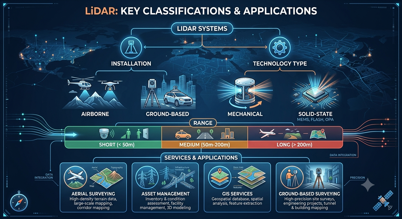
Traditional mechanical LiDAR systems use moving components to scan their surroundings. While mechanical systems offer wide fields of view and long-range capabilities, solid-state technologies can provide advantages in terms of compactness, reliability, scalability, and integration.
Solid-state LiDAR is particularly relevant to automotive applications where sensors need to be integrated into vehicle designs without significantly affecting aesthetics or aerodynamics.
As manufacturers seek to reduce sensor costs and improve performance, innovations in solid-state architectures are expected to support broader LiDAR deployment in passenger vehicles and commercial fleets.
Ground-Based LiDAR Gains Market Share
By installation, ground-based LiDAR holds the larger market share and is expected to grow faster than airborne LiDAR during the forecast period.
MarketsandMarkets attributes this growth to relatively lower costs and less stringent approval requirements for mapping and surveying applications. Ground-based systems are used across environmental monitoring, meteorology, corridor mapping, ADAS, and autonomous vehicle applications.
Ground-based LiDAR is also valuable for infrastructure inspection and engineering projects. It can generate detailed 3D models of roads, bridges, buildings, industrial facilities, and other assets.
As governments and private organizations invest in infrastructure modernization, demand for accurate digital representations of physical environments is likely to increase.
Download PDF Brochure @ https://www.marketsandmarkets.com/pdfdownloadNew.asp?id=1261
UAV LiDAR Creates New Surveying Opportunities
The growing adoption of UAV-based LiDAR systems is another major driver of the LiDAR Market.
Drones equipped with LiDAR sensors can capture accurate data in locations that may be difficult, dangerous, or expensive to access using conventional surveying techniques. UAV LiDAR can be deployed for infrastructure inspection, environmental monitoring, forestry, mining, corridor mapping, and engineering projects.
One major advantage is the ability to create detailed digital elevation models and three-dimensional representations of terrain.
UAV LiDAR can also reduce the time and manpower required for certain surveying projects. As drone technology becomes more capable and regulations evolve, the combination of UAVs, LiDAR, AI, and cloud-based processing is expected to create additional opportunities.
Short-Range LiDAR Supports Robotics and Security
By range, short-range LiDAR is projected to lead the market, driven by adoption in automobiles, security systems, and robotics.
Short-range systems are particularly useful where accurate detection of nearby objects is required. Robotics applications can use LiDAR for localization, navigation, obstacle avoidance, and environmental mapping.
In warehouses and industrial facilities, LiDAR can support autonomous mobile robots and automated material-handling systems. Security applications can use LiDAR to detect movement and monitor defined areas.
The increasing adoption of automation across warehouses, factories, logistics centers, and commercial facilities is therefore creating new demand for compact LiDAR sensors.
Digital Twins and 3D Mapping Transform Infrastructure
Another major LiDAR Market trend is the integration of LiDAR data with digital twins and 3D modeling platforms.
Digital twins create digital representations of physical assets or environments. LiDAR can provide highly accurate spatial information required to construct and update these models.
Infrastructure developers can use LiDAR to create digital models of roads, bridges, railways, buildings, utilities, and urban areas. These models can support planning, construction, maintenance, inspection, and asset management.
Smart city initiatives are also increasing demand for detailed geospatial information. Governments can use LiDAR-generated data to support urban planning, transportation management, environmental monitoring, and infrastructure development.
MarketsandMarkets identifies investments in digital twins, 3D mapping, smart cities, and urban planning as important contributors to LiDAR adoption.
AI and Cloud Processing Enhance LiDAR Data
LiDAR systems generate large volumes of spatial data. Processing this information efficiently is becoming increasingly important.
AI and machine learning can analyze point clouds to identify objects, classify terrain, detect changes, and extract useful information. Cloud platforms can provide scalable computing resources for processing large datasets generated by aerial and ground-based surveys.
This combination of LiDAR, AI, and cloud computing can shorten processing times and enable organizations to manage increasingly complex geospatial datasets.
The LiDAR Market is therefore evolving from a hardware-focused industry toward a broader ecosystem involving sensors, software, analytics, cloud infrastructure, and specialized services.
Aerial Surveying Remains a Major Service Segment
By service, aerial surveying is projected to hold the largest share of the LiDAR Market.
Aerial LiDAR can be deployed using aircraft and unmanned aerial systems to survey large areas efficiently. Applications include inspection and monitoring of roads, railways, highways, bridges, forests, mining sites, and other large-scale environments.
The growing need for infrastructure development and environmental management is supporting demand for aerial surveying.
LiDAR can provide accurate elevation information even in areas where conventional optical surveying methods may face limitations. This makes it particularly valuable for terrain mapping and complex environments.
Environmental Monitoring Expands Market Potential
Environmental applications represent another significant opportunity for the LiDAR Market.
LiDAR can support forest management, vegetation analysis, flood modeling, terrain mapping, coastal monitoring, and environmental change detection.
Its ability to collect detailed three-dimensional information allows organizations to monitor changes in landscapes over time.
Climate-related challenges and increasing emphasis on sustainable resource management are likely to create additional demand for accurate environmental data.
LiDAR can also be used in mining and natural-resource exploration to map terrain and support planning activities.
Asia Pacific Emerges as the Fastest-Growing Region
Asia Pacific is projected to register the highest CAGR in the global LiDAR Market, with the regional market expected to grow from USD 0.92 billion in 2025 to USD 4.01 billion by 2030, representing a CAGR of 34.1%.
Growth in the region is supported by infrastructure development, smart city programs, autonomous and electric vehicle investments, industrial automation, robotics, and drone-based surveying.
China, Japan, and other Asian economies are investing heavily in transportation infrastructure and advanced mobility technologies. The region’s strong manufacturing ecosystem is also supporting the development and deployment of LiDAR sensors.
India is another emerging market. MarketsandMarkets projects India’s LiDAR Market to increase from USD 26.3 million in 2025 to USD 106.4 million by 2030, representing a CAGR of 32.3%.
Growth Opportunities in the LiDAR Market
Several opportunities are expected to shape the future of the LiDAR Market.
Automotive ADAS and Autonomous Driving
Automotive companies are investing heavily in ADAS and autonomous driving technologies. This creates opportunities for LiDAR manufacturers capable of delivering compact, reliable, cost-effective, and high-performance sensors.
UAV-Based Mapping
The increasing use of drones for surveying and inspection is expanding the addressable market for lightweight LiDAR systems.
Smart Cities
Urban governments are increasingly using 3D mapping and digital twins for transportation, infrastructure planning, and environmental management.
Robotics and Automation
Warehouse automation, industrial robotics, and autonomous mobile robots require reliable perception technologies, creating opportunities for short-range LiDAR.
Environmental Monitoring
Forest management, climate monitoring, mining, agriculture, and disaster management can benefit from accurate three-dimensional environmental data.
Challenges Could Limit Adoption
Despite strong growth prospects, the LiDAR Market faces several challenges.
One major restraint is competition from low-cost and lightweight photogrammetry systems. Photogrammetry can generate 2D and 3D models at a lower cost, making it an attractive alternative for certain mapping and surveying applications.
High post-processing costs can also limit adoption, particularly for smaller organizations. MarketsandMarkets notes that LiDAR surveying equipment and post-processing software can involve significant costs.
Miniaturizing LiDAR sensors while maintaining accuracy, range, reliability, and affordability is another technical challenge.
The industry must therefore continue reducing sensor costs while improving performance and simplifying data processing.
Competitive Landscape
The competitive environment includes companies developing LiDAR sensors, mapping solutions, surveying systems, automotive technologies, and software platforms.
Key companies identified by MarketsandMarkets include Hesai Group, RoboSense Technology, SICK AG, Ouster, Luminar Technologies, Leica Geosystems, Trimble, Teledyne Optech, FARO Technologies, RIEGL Laser Measurement Systems, NV5 Geospatial, Beijing SureStar Technology, and YellowScan.
Product launches, partnerships, acquisitions, and technology development are among the strategies being used to strengthen market positions.
For example, Ouster introduced 3D Zone Monitoring for its REV7 digital LiDAR sensor lineup in March 2025, enabling customized 3D detection zones and real-time alerts for applications such as warehouse automation and industrial robotics.
Future Outlook for the LiDAR Market
The future of the LiDAR Market will be defined by the convergence of 3D sensing, AI, autonomous systems, robotics, digital twins, cloud computing, and smart infrastructure.
As sensors become smaller, more affordable, and more capable, LiDAR is likely to expand into applications that were previously limited by cost or technical complexity.
The market’s projected growth from USD 3.27 billion in 2025 to USD 12.79 billion by 2030 highlights the scale of this transformation.
LiDAR is increasingly becoming more than a mapping technology. It is evolving into a critical perception technology for machines and intelligent infrastructure.
From autonomous vehicles navigating complex roads to drones surveying remote terrain and robots operating inside warehouses, LiDAR is enabling machines to understand the physical world with greater precision.
As digital transformation continues, the organizations that successfully combine LiDAR hardware with AI, software, analytics, and cloud technologies will be positioned to capture emerging opportunities across mobility, infrastructure, industrial automation, environmental monitoring, and geospatial intelligence.
Frequently Asked Questions
1. What is the LiDAR Market?
The LiDAR Market covers technologies, systems, and services that use laser-based sensing to measure distances and create detailed three-dimensional representations of objects and environments. Major applications include surveying, mapping, autonomous vehicles, ADAS, robotics, infrastructure, environmental monitoring, and urban planning.
2. How large is the LiDAR Market?
According to MarketsandMarkets, the global LiDAR Market was valued at USD 3.27 billion in 2025 and is projected to reach USD 12.79 billion by 2030, growing at a CAGR of 31.3% during 2025–2030.
3. What are the major trends in the LiDAR Market?
Key trends include the adoption of solid-state LiDAR, integration with AI and cloud computing, increasing UAV-based surveying, autonomous vehicle deployment, 3D mapping, digital twins, robotics, and the development of lightweight and high-speed scanning systems.
4. Which region is expected to grow fastest in the LiDAR Market?
Asia Pacific is expected to be the fastest-growing regional market. MarketsandMarkets projects the region to grow at a 34.1% CAGR from 2025 to 2030, supported by infrastructure development, autonomous vehicles, smart cities, industrial automation, and drone-based surveying.
5. What are the key challenges facing the LiDAR Market?
Major challenges include the availability of lower-cost photogrammetry alternatives, high post-processing software costs, complexities associated with sensor miniaturization, and the need to balance cost, accuracy, range, and performance.
